- Blog
Not Quite Ready For The Tongariro Crossing Challenge? Try the Tama Lakes Track Instead
The Tongariro Crossing is a popular tourist attraction in New Zealand. Many visitors to this country include it on their “bucket lists.”
However, it can be a challenging hike. You’ll be ascending over 1,000 metres, and at some stages, you’ll be walking over loose rocks.
Weather can change quickly, and depending on the season, it can be extremely harsh.
So, depending on your level of fitness, the Tongariro Crossing may not be your best option. The views are breathtaking, but for a first time hiker there may be other options.
Is there a hike in New Zealand that is equally beautiful but less physically challenging?
The track to the Tama Lakes
Although the Tama Lakes Track is less popular than the Tongariro Crossing, it offers equally stunning views and is much easier and more accessible. The trail’s proximity to Whakapapa Village and its beautiful landscapes make it a favourite for many hikers.
Highlights include a breathtaking waterfall midway and spectacular views of Mt. Ngauruhoe (Mount Doom from Lord of the Rings) and Mt. Ruapehu.
The track provides similar alpine scenery without the steep climbs and challenging weather conditions of the Tongariro Crossing.
The Hike
The Taranaki Falls Track leads you through a beautiful alpine shrubland with purple and white wildflowers and a fairytale-like beech forest with moss-covered trees and a babbling brook before arriving at the falls.
From there, you’ll follow well-marked paths and boardwalks through tussock country and alpine herb fields to the lakes.
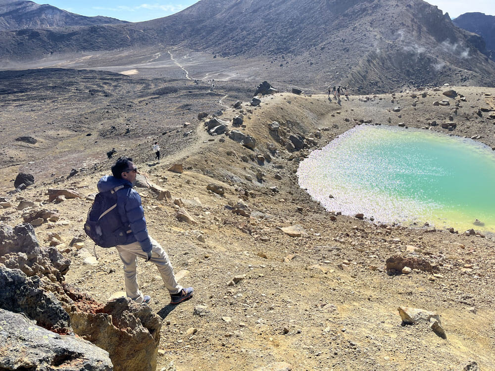
The 35-minute ascent to the 1,440-metre-high Upper Lake viewpoint is not difficult, though the volcanic screen makes some sections of the path slippery enough that you may have to walk sideways on the way down.
But it’s well worth it for the 360-degree view of this section of National Park, which contains some of the oldest lava flows on the slopes of Mount Ngauruhoe and Ruapehu, as well as the old scars of glacial cycles that once tore it apart.
The Tama Lake Track vs. the Tongariro Crossing
At Tongariro Crossing, the weather is constantly changing, and there are many bad days.
People are advised to avoid the track between June and October, when it becomes snowy and/or icy.
However, things can get pretty scary at any time of year.
It is common to have cold weather, strong winds, heavy rain, poor visibility, and snow even in the middle of summer.
Because it is in the same alpine area, the DOC warning also applies to the Tama Lakes Track.
However, the department states on its website that because it is more protected, it “may be a great alternative when the weather is bad.”
What you need to know
To get to the two lakes, follow the well-kept track past Taranaki Falls and between two active volcanoes in Tongariro National Park, Ruapehu and Ngauruhoe (sitting in craters left over from old vent explosions).
- Length: 17 km round trip, mostly flat until the final ascent to Upper Tama.
- Time required: 2 hours to return to Taranaki Falls, 6 hours (via a different route) to return to Tama Lakes.
- Difficulty: Although the trail is mostly flat and easy, it is quite long. Extremely vulnerable to bad weather, especially near lakes.
- Facilities: Whakapapa Village, where the track begins, has cafes, public restrooms, and a visitor centre. On the ridge near Upper Tama Lake, there is a small shelter with a rock wall (mid-left in above photo).
Frequently Asked Questions about the Tama Lakes Track
How long is the Tama Lakes walk?
Tama Lakes is a short walk that will take you between 5 and 6 hours to complete. The trail begins at Ngauruhoe Place, 100 metres below the Whakapapa Visitor Centre in Whakapapa Village.